
Immigrant heritage in the German villages, memories of the railway and a walk Strobel Diamante, door to the National Park preserving ecosystems levee, the lake and bathed landscapes that characterize this stretch of coastline. Ideal for the purposes of entrerrianos week matte and nature walk.
Between Paraná and Victoria, the RP 11 is the thread that links the German villages in the province of Entre Rios. They are the people who founded the mid-nineteenth century communities "Volga Germans" in the new country that opened them the doors after being forced from Czarist Russia.
The first five were founded in 1878; Valle were Marienthal or Mary; Protestant; Marienfeld or Spatzenkutter; San Francisco; Santa Cruz. Later it would be the turn of Brazilian village where settlers who had initially been settled in Brazil.

The German villages are now a circuit itself, which travels to meet a string of villages where architectural remains of those people are and, above all, a strong gastronomic seal. As in Corner Munich, a classic Brazilian village, where you have the "restaurant version" of the dishes that many families still eat home indoors with stews and Central Filsen to the head.
Every year on December 8 December, delegations leaving Brazilian village, Valle Maria and Spatzenkutter leave in procession by the Place de la Virgen, on the banks of the Parana, to a cave near the canyon. On the way there are several hostels where you can take a break, or even navigate part of the way. For closer or farther away from the coast, the river is the presence that always unites the most diverse corners of the province.

STROBEL RIDE.
Less than ten kilometers of Aldea Protestant, Strobel is the last stop before Diamante, which in turn is the gateway to Predelta National Park. They can be explored on foot, along a path that runs parallel aa railway line, between silos and trees that lead to a little park railway consists of a locomotive and some wagons.
Walking the Paseo de la Ribera Diamond, near which the creation of a Ramsar international convention -the protects wetlands-can also join the trek of the islands that allow, when in season, watch the flowers is projected site I irupé identifying the National Park.

The walk Diamante also worth spending some time at the Museum of Dr. Liotta, born in the city and known for creating the artificial heart. In the halls you can see from their creations in the field of medicine to the prizes and gifts he received during his career: the most outstanding milestone was the first use of a total artificial heart during a heart transplant in April 1969 the Texas Heart Institute in Houston.
Leaving behind Diamond to continue the coastal walk, the neighborhood of fishermen is distinctive for its statue of Christ Pescador, striking 12 meters high and 14 tons. It was installed at the initiative of a sister of the Servants of the Holy Spirit, closely linked with the Volga Germans here. Those who have seen the Malvinas Monument in Quequén, or the Monument to the Sower in Villa Elisa, as well as Bicentennial Monument in Neuquen, probably recognize the hand of the sculptor Andrés Mirwald in the course of the work. Here and there, still they appear Palanqueros fishermen with their fishing cargo in tow, as traditionally as ever.
PUNTA GORDA AND ROOF.
The trip continues in Punta Gorda, the place where Urquiza crossed the Parana which in this sector is more angosto- to go towards the battle of Caseros. With crossed cannons and thousands of soldiers, at the beginning of a journey that would take one month to the province of Buenos Aires. It was carried horses as "scourge", a form that allowed them arrear many animals at once, with a gaucho that egged and another that ran from inside the pack. So today the place is known as the roof. Here are also old vessels, such as ships used cages used to transport animals, and old fishing boats anchored in the past.
go a coastline rich in vines and trees like timbó and dragon's blood, two species very characteristic of the place. It is a world of pure nature, where traces of capybaras, birdsong and flavors that speak of herbs and pure vegetation where they mix from ombúes carnations air to guess. You can walk along a path that passes from the levee to the woods and then towards the end canyon.
You get -now herself at the end and main point of the trip: the Predelta National Park, symbolized by a kingfisher, a bird long beak that is usually seen frequently waiting patiently for their prey on the branches near the shore.

The park has a clear goal: the preservation of the ecosystem of the levee (ie the highest point) of the lagoon, and bathed (the lower and more flood-prone area of the set). It is the habitat of water cockerels, cuervillos, otters, nutria and many birds that attract photographers and birdwatchers. The road -cuentan rangers guarding these litoraleños- everyday landscapes slowly into streams and brooks, which are like the streets of Delta opens. Streets where it is easier to navigate than walking, and that still remain traditional lifestyles well inside. It is indeed the only place left to know the true Delta as it was, and further south the environment is greatly modified by human intervention and agriculture.
National Park, which covers part of the Parana river and islands Del Ceibo, sleeves and Del Barro, is also revealing of the times: with increasing frequency appear like the Pope-maned species that are very forested, more north, but using the river as a corridor: and also pushed by the notorious climate change were down and today the sights in the province of Entre Rios.
The protected area is also home to the Carau, the only American crane, and armadillos, cardenillas, thrushes and woodpeckers Chaco, among other species. With watchful eyes will not soon discover traces of the passage of several animals more: a flattened pajonal simple can be a symbol of a nearby capybara that was lying around here, watching the embalsados of camalotes run slowly through the water. There are also otters, otters, alligators, speckled lizards, turtles, ducks, screamers ... it is a whole world that lives mostly half-hidden among the tall grass, but less attentive to the passage of a strange visitor.
Somehow it is a mutual exercise, which threatens wildlife spy to take care of the newcomer, and the curious humans of this world quite rightly flees them. But the Predelta National Park is just ideal for a meeting point between the two place.

Between Paraná and Victoria, the RP 11 is the thread that links the German villages in the province of Entre Rios. They are the people who founded the mid-nineteenth century communities "Volga Germans" in the new country that opened them the doors after being forced from Czarist Russia.
The first five were founded in 1878; Valle were Marienthal or Mary; Protestant; Marienfeld or Spatzenkutter; San Francisco; Santa Cruz. Later it would be the turn of Brazilian village where settlers who had initially been settled in Brazil.

The German villages are now a circuit itself, which travels to meet a string of villages where architectural remains of those people are and, above all, a strong gastronomic seal. As in Corner Munich, a classic Brazilian village, where you have the "restaurant version" of the dishes that many families still eat home indoors with stews and Central Filsen to the head.
Every year on December 8 December, delegations leaving Brazilian village, Valle Maria and Spatzenkutter leave in procession by the Place de la Virgen, on the banks of the Parana, to a cave near the canyon. On the way there are several hostels where you can take a break, or even navigate part of the way. For closer or farther away from the coast, the river is the presence that always unites the most diverse corners of the province.

STROBEL RIDE.
Less than ten kilometers of Aldea Protestant, Strobel is the last stop before Diamante, which in turn is the gateway to Predelta National Park. They can be explored on foot, along a path that runs parallel aa railway line, between silos and trees that lead to a little park railway consists of a locomotive and some wagons.
Walking the Paseo de la Ribera Diamond, near which the creation of a Ramsar international convention -the protects wetlands-can also join the trek of the islands that allow, when in season, watch the flowers is projected site I irupé identifying the National Park.

The walk Diamante also worth spending some time at the Museum of Dr. Liotta, born in the city and known for creating the artificial heart. In the halls you can see from their creations in the field of medicine to the prizes and gifts he received during his career: the most outstanding milestone was the first use of a total artificial heart during a heart transplant in April 1969 the Texas Heart Institute in Houston.
Leaving behind Diamond to continue the coastal walk, the neighborhood of fishermen is distinctive for its statue of Christ Pescador, striking 12 meters high and 14 tons. It was installed at the initiative of a sister of the Servants of the Holy Spirit, closely linked with the Volga Germans here. Those who have seen the Malvinas Monument in Quequén, or the Monument to the Sower in Villa Elisa, as well as Bicentennial Monument in Neuquen, probably recognize the hand of the sculptor Andrés Mirwald in the course of the work. Here and there, still they appear Palanqueros fishermen with their fishing cargo in tow, as traditionally as ever.
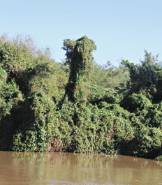
Typical hummocks formed by building up vegetation on the trees.
PUNTA GORDA AND ROOF.
The trip continues in Punta Gorda, the place where Urquiza crossed the Parana which in this sector is more angosto- to go towards the battle of Caseros. With crossed cannons and thousands of soldiers, at the beginning of a journey that would take one month to the province of Buenos Aires. It was carried horses as "scourge", a form that allowed them arrear many animals at once, with a gaucho that egged and another that ran from inside the pack. So today the place is known as the roof. Here are also old vessels, such as ships used cages used to transport animals, and old fishing boats anchored in the past.
go a coastline rich in vines and trees like timbó and dragon's blood, two species very characteristic of the place. It is a world of pure nature, where traces of capybaras, birdsong and flavors that speak of herbs and pure vegetation where they mix from ombúes carnations air to guess. You can walk along a path that passes from the levee to the woods and then towards the end canyon.
You get -now herself at the end and main point of the trip: the Predelta National Park, symbolized by a kingfisher, a bird long beak that is usually seen frequently waiting patiently for their prey on the branches near the shore.

The park has a clear goal: the preservation of the ecosystem of the levee (ie the highest point) of the lagoon, and bathed (the lower and more flood-prone area of the set). It is the habitat of water cockerels, cuervillos, otters, nutria and many birds that attract photographers and birdwatchers. The road -cuentan rangers guarding these litoraleños- everyday landscapes slowly into streams and brooks, which are like the streets of Delta opens. Streets where it is easier to navigate than walking, and that still remain traditional lifestyles well inside. It is indeed the only place left to know the true Delta as it was, and further south the environment is greatly modified by human intervention and agriculture.
National Park, which covers part of the Parana river and islands Del Ceibo, sleeves and Del Barro, is also revealing of the times: with increasing frequency appear like the Pope-maned species that are very forested, more north, but using the river as a corridor: and also pushed by the notorious climate change were down and today the sights in the province of Entre Rios.
The protected area is also home to the Carau, the only American crane, and armadillos, cardenillas, thrushes and woodpeckers Chaco, among other species. With watchful eyes will not soon discover traces of the passage of several animals more: a flattened pajonal simple can be a symbol of a nearby capybara that was lying around here, watching the embalsados of camalotes run slowly through the water. There are also otters, otters, alligators, speckled lizards, turtles, ducks, screamers ... it is a whole world that lives mostly half-hidden among the tall grass, but less attentive to the passage of a strange visitor.
Somehow it is a mutual exercise, which threatens wildlife spy to take care of the newcomer, and the curious humans of this world quite rightly flees them. But the Predelta National Park is just ideal for a meeting point between the two place.
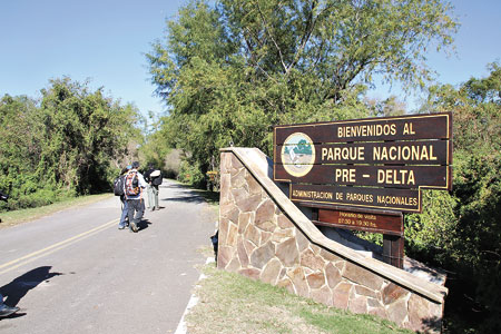
The access road to Predelta National Park.
If you liked this article, subscribe to the feed by clicking the image below to keep informed about new contents of the blog:


