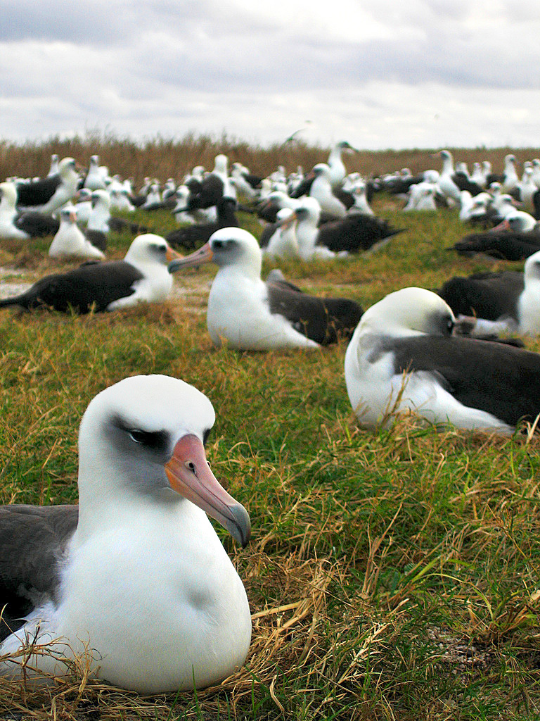
The Malvinas Islands (Falklands) host a unique ecosystem shaped by their cold, windy climate and isolation. The fauna is dominated by marine mammals and seabirds, while the flora consists mainly of grasses, shrubs, and peat bog vegetation, with no native trees.

Flora of the Malvinas Islands

  • Grasslands and Shrubs: The islands are largely covered by tussac grass (Festuca flabellata), which can grow up to 2 meters tall and provides shelter for birds and sea lions.

  • Peat Bogs: Extensive peatlands support mosses and small herbaceous plants.

  • Heathlands: Areas with dwarf shrubs and hardy plants adapted to poor soils and strong winds.

  • Endemic Plants: Species such as Malvinas Daisy (Perezia recurvata) and Malvinas Violet (Viola maculata) are unique to the islands.

  • Absence of Native Trees: No native arboreal vegetation exists today, though fossil records show ancient cypress and araucaria forests.

Fauna of the Malvinas Islands

Marine Mammals
  • Seals and Sea Lions: Southern sea lions, elephant seals, and fur seals are common along the coasts.

  • Cetaceans: Orcas, dolphins, and several whale species migrate through surrounding waters.

Birds
  • Penguins: Five species breed here: King, Gentoo, Rockhopper, Macaroni, and Magellanic penguins.

  • Seabirds: Albatrosses, petrels, cormorants, and skuas thrive in the nutrient-rich waters.

  • Land Birds: The Falkland steamer duck (flightless), upland goose, and the endemic Cobb’s wren are notable.

Invertebrates
  • Endemic Beetles: Several species of ground beetles and weevils are unique to the islands, such as Malvinius compressiventris.

Conservation Notes

  • Fragile Ecosystem: The harsh climate limits biodiversity, making species highly specialized and vulnerable.

  • Threats: Introduced species (rats, cats) have impacted native bird populations.

  • Protection Efforts: Conservation programs focus on seabird colonies and restoring tussac grass habitats.

Quick Comparison Table

Category
Key Species/Features
Notes

Flora
Tussac grass, peat bog mosses, endemic daisies
No native trees; vegetation adapted to wind/cold

Marine Mammals
Sea lions, elephant seals, dolphins, whales
Coastal and migratory presence

Birds
Penguins (5 species), albatrosses, Cobb’s wren
Major global seabird colonies

Invertebrates
Endemic beetles, weevils
High endemism despite low diversity

In short: the Malvinas Islands are a haven for seabirds and marine mammals, with vegetation dominated by tussac grass and peat bogs. Their isolation has fostered unique endemic species, but conservation is crucial to protect this fragile ecosystem.

Before going on a trip to the province of San Juan, I only had one trip in mind that I had to do and that was to go visit the famous "Valley of the Moon". Once I was there I discovered that the correct name of this place is Parque Ischigualasto and that there were many more surprises there than just the few photos that were shown on the internet. Discovering all these beautiful landscapes with my own eyes was one of the best things I did this year, and after all the surprises I saw along the way, I was finally in front of the typical postcard of this place ❤️.


Pinmapple (18x12) (2).png


My hostel co-worker and I traveled almost four hours to get from the city center to the park. This trip was a little tiring, but we still knew it was worth it when we were finally there. This place, made up of more than 60 thousand hectares of clay terrain, houses the most beautiful landscapes of this province. What I liked the most is that these were unique for me since I had never seen anything like this in any other province ❤️.

IMG_20230924_155843090~2.jpg IMG_20230924_154323555~2.jpg IMG_20230924_154906141~2.jpg


In total, the visit to this park took us about 4 hours. In it we traveled more than 40 km of road aboard a public bus provided by the park itself. On the walk we stopped to see five places of interest, such as the Painted Valley, the Bocce Field, the Dr William Sill Site Museum and the El Submarino geoforomas. Each one of them had its special touch, and at the end of the path it was time to discover the famous mushroom ❤️.

IMG_20230924_154836513~2.jpg IMG_20230924_155522346~2.jpg


This geoform is the typical postcard of this park, and is even the logo of the park itself. I think its popularity is due to the fact that it is the one closest to the large reddish wall in the background, which serves as the natural boundary between the provinces of La Rioja and San Juan. The colors of both materials create a great contrast and its popularity is well deserved ❤️.

IMG_20230924_155754405~2.jpg IMG_20230924_155021596.jpg IMG_20230924_155131625.jpg IMG_20230924_155632444~2.jpg


The funniest anecdote from this day is that it took me quite a while to get the ticket to visit this place. Due to failures in the ticket sales system, I had to go to the bus station four times until I finally got my seat. This walk was scheduled for a Sunday, and on Saturday night, at the last minute, my partner decided to go with me. His idea was to approach the bus at departure time to ask if they would sell him a ticket at that moment, and he was so lucky that they did. It didn't cost him anything to get a place, and then he laughed at me and my whole ordeal .

IMG_20230924_155449655~2.jpg IMG_20230924_155401292~2.jpg


I quite liked having my friend's company that day. There we took the opportunity to talk about my desire to travel alone for a long time and about all the times I imagined myself in front of that figure, achieving my fiancé. The truth is that this trip encouraged me to travel alone more often, because after all, friends are made along the way ❤️.

IMG_20230924_155727983~2.jpg IMG_20230924_154924616~2.jpg


This was the last stop of our walk and to return to the park gate, we did so alongside the large orange wall that we were seeing during the afternoon. This large wall, about 30 meters high, extended the entire length of the park and contrasted very well with all the pale landscapes we had been seeing ❤️.

IMG_20230924_160514161.jpg IMG_20230924_160548581.jpg IMG_20230924_160612630.jpg IMG_20230924_161837843.jpg


From the bus in which we were traveling we were lucky enough to come across some guanacos in their natural habitat. In addition to these cute animals, you can also see small foxes, condors, small rodents and even pumas in this park. This place is really sprawling, so I imagine thousands of families live around here .

IMG_20230924_161840877.jpg IMG_20230924_162204023.jpg IMG_20230924_162321662~2.jpg


This walk ended with a short stop at the dinosaur museum at the entrance, where some of the specimens found here were on display. This entire place is oriented towards these prehistoric animals, since to this day studies are carried out on the findings that were found here. The truth is that it is highly recommended to visit this place, because you will definitely learn something new ❤️.


IMG_20230924_162424155.jpg IMG_20230924_162719389~2.jpg IMG_20230924_164839127~2.jpg IMG_20230924_164403658.jpg


Visiting Ischigualasto Provincial Park was something very beautiful and memorable for my partner and me. Even though the four-hour return trip left us more than tired (we arrived at the hostel straight to sleep), going there was worth it. While I was in that place I thought about how lucky I am to be able to achieve what I set out to do, and to delight my eyes with the landscapes I want to see. I hope that you also liked it as much as I did and that if you ever visit Argentina, don't hesitate to take a getaway to San Juan ❤️.

source

Cerro Pirque in Chubut, Patagonia, has been burning for several days due to summer forest fires, destroying one of the last virgin Andean-Patagonian forests and threatening endangered species like the huemul deer. Experts warn the damage could be irreversible, with biodiversity loss and ecosystem collapse highly likely.

Key Facts About the Fire

  • Location: Cerro Pirque, near Puerto Patriada and Lago Epuyén, Chubut, Argentina.

  • Duration: The fire has been active for at least four consecutive days.

  • Cause: Authorities suspect intentional ignition, worsened by drought, high temperatures, and strong winds.

  • Scale: More than 60 hectares have already been affected in past incidents, and current damage is spreading rapidly.

  • History: Cerro Pirque has suffered four major fires since 1987, showing a recurring vulnerability.

Biodiversity at Risk

  • Huemul deer (Hippocamelus bisulcus): Critically endangered, with Cerro Pirque serving as a rare refuge.

  • Virgin Andean-Patagonian forests: These ecosystems are unique, hosting native species of flora and fauna found nowhere else.

  • Irreversible damage: Specialists warn that the loss of primary forest cover could permanently alter the ecological balance.

Environmental Impact

  • Habitat destruction: Loss of nesting and feeding grounds for birds, mammals, and insects.

  • Soil degradation: Fires strip protective vegetation, increasing erosion and reducing regeneration capacity.

  • Carbon emissions: Large-scale release of stored carbon worsens climate change.

  • Water systems: The fire threatens watersheds feeding Lago Epuyén, impacting local communities and tourism.

Challenges in Containment

  • Topography: Steep slopes make firefighting difficult.

  • Weather: Strong winds accelerate fire spread.

  • Resources: Local brigades face limited equipment and manpower.

  • Negligence: Past fires have been linked to poor handling of ashes and human activity.

Broader Context

  • Climate change: Rising temperatures and prolonged droughts increase fire frequency and intensity.

  • Human factor: Intentional or negligent ignition remains a major driver of forest fires in Patagonia.

  • Conservation urgency: Protecting Cerro Pirque is critical for maintaining biodiversity corridors in the southern Andes.

Takeaway

The summer forest fires on Cerro Pirque represent an ecological tragedy, threatening endangered species and unique ecosystems. Immediate containment is essential, but experts caution that long-term recovery may be impossible if virgin forests are lost. Strengthening fire prevention, monitoring, and conservation policies in Patagonia is now more urgent than ever.

With the aim of challenging myself more and more, during my stay in the province of San Juan I decided to do all the trekking that was within my reach. For us who live in the city, being surrounded by mountains from time to time is a real treat, so I wanted to spend most of my time seeing these types of landscapes. After having made several walks in the surroundings, my hostel companion, who recommended the walks, "enabled" us to do one of the longest treks in the area, and of course I wanted to be there to show myself that I could get to complete it ❤️.


Pinmapple (18x12) (4).png


Since my hostel partner had already visited San Juan several times, she already knew almost all the paths to follow. She was in charge of suggesting (but without join us) hikes for us in order of increasing difficulty, so that our body could get used to the demands of the climbs and long distances. When she finally noticed that our physical condition was capable of withstanding the climbs and physical effort well, she recommended that we do one of the most emblematic treks in the area: crossing from Zonda (red mark) to Ullum (blue mark), walking over of the mountains. This walk can be done in either direction, and the good thing is that at both ends you have public transportation to the city, which makes it a one-way route ❤️.

Trail to complete in the trek from Zonda to Ullum.
Sendero a completar en el trekking desde Zonda hasta Ullum.
image.png


The initial information they had given us about this trek was that it would take us about 6 hours to complete, a time that my companions and I thought we would spend without problems. They also recommended that we start early in the morning on a day without much wind, since walking completely on the top could be dangerous. In addition to bringing plenty of cold water, we also had to bring plenty of sunscreen and enough food to last those supposed six hours. I must say that we did everything except bringing a lot of food, since we underestimated the effort it would take us to complete this section and we didn't have as many snacks, but we still survived .

IMG_20231005_102133939.jpg IMG_20231005_103312794.jpg IMG_20231005_104632973.jpg


The beginning of the trail was from the Zonda area, where we arrived by bus around 10 AM. In previous days we had already been there so we knew the first part well: to go to the beginning you must climb the same as to go to see the head of the Indian, only instead of To follow a civilized path, you must climb a little to the top .

IMG_20231005_110639366.jpg IMG_20231005_111246918.jpg IMG_20231005_110636149.jpg


As we went up, we were able to get some great views of the Zonda Valley, with its olive and grape plantations. There were also some vacation houses around and a few other wineries, but preserving plenty of green space in the place. Behind everything we could see the other great mountainous area of this place: the Sierras Azules ❤️.

IMG_20231005_111317912.jpg IMG_20231005_110633361.jpg IMG_20231005_105837611~2.jpg IMG_20231005_110949341.jpg IMG_20231005_104629345.jpg IMG_20231005_111323520_HDR.jpg


Once we crossed the first part of this path, which we had to climb using our arms and legs, we found a well-marked and seemingly easy trail. As we chose to go early, the sun was reaching its highest point so we had all the light available to see, knowing that we had to walk in the direction of the dam. From up there we could see what we had already seen in previous days, such as the abandoned racetrack, the abandoned hotel and also the municipal field ❤️.

IMG_20231005_112143284.jpg](18)![IMG_20231005_113201827.jpg IMG_20231005_123305144.jpg IMG_20231005_123310396.jpg IMG_20231005_112147057.jpg IMG_20231005_113157226.jpg IMG_20231005_123815835.jpg IMG_20231005_111302697.jpg


An hour and a half after starting to walk, we find the highest peak of these mountains. At only 1110 meters above sea level, this place offered a great panoramic view of the valley and its surroundings. To symbolically mark this place, there was a cross and a grotto, so it was impossible to miss it. It was also a place to sit and rest and eat our humble lunch, since there were no traces of what we had had for breakfast .

IMG_20231005_132827328.jpg IMG_20231005_135035271.jpg IMG_20231005_124448658.jpg IMG_20231005_133115345.jpg IMG_20231005_134119778.jpg IMG_20231005_124435554.jpg


It was at this first peak where we saw a sign indicating that the descent to Ullum would take about 5 hours. Becoming professional trekkers, we thought that it would take us much less time to travel this section, since from up there we could already see the dam and "it didn't seem to be that far away" .

IMG_20231005_133126660.jpg IMG_20231005_133305668.jpg IMG_20231005_133829291.jpg


Well, this assessment of "not being that far from the dam" was correct if we looked in a straight line, but we found ourselves walking over some mountain ranges that went up and down all the time. So, this journey was like climbing small hills over and over again, where of course we needed stops to rest and regain strength in our legs .

IMG_20231005_111310280.jpg IMG_20231005_113245291.jpg IMG_20231005_123301055.jpg IMG_20231005_143648286.jpg


It would be around 3 PM when we finally reached what my hostel companion pointed out as "the halfway point." This place was easily distinguishable because we would find some stone shelters against the wind. These constructions serve as protection for those who choose to spend the night here, or in case you are caught by the gusts at that time. Luckily, the weather was beautiful and none of that was necessary ❣️.

IMG_20231005_145803201.jpg IMG_20231005_161431789.jpg IMG_20231005_150049896.jpg IMG_20231005_142725002.jpg](15)![IMG_20231005_150113832.jpg IMG_20231005_145819670.jpg


We had been walking for five hours and although the dam looked closer and closer, it already seemed that in just one hour we would not finish the entire journey as we had been told. Perhaps some hiker focused on finishing the trail will make it in that time, but with my companions we were relaxed so we took all our time, in total there was still plenty of sun ahead ❤️.

IMG_20231005_144745199.jpg IMG_20231005_144835623.jpg


A funny anecdote from this day, which I was later able to recognize from the photos I took along the way, is that at one point we left the main path and that detour cost us more than an extra hour of walking. After a while we noticed that we were not on the correct path, but in that part the mountain had a kind of ravine and could only be crossed by going back and taking the correct path. My friends and I of course did not admit our mistake and continued walking forward, until we were able to go down in part and go up to return to the true path .

IMG_20231005_151411770.jpg IMG_20231005_151402877.jpg


The afternoon was passing and we were still walking: we had already eaten all our provisions and the water was also running out, even though there was still a good stretch to go. At this moment we began to feel really tired, but we were so close to completing the route that that was what motivated us to continue (added to the fact that we were at the top of the mountains, who could go looking for us without making such a fuss? ).

IMG_20231005_143645242.jpg IMG_20231005_171116621.jpg IMG_20231005_161426006.jpg


When the mountains began to change their dark color to orange, we knew that we were already very close to the Tres Marías area, which we had also visited days before. It was really crazy to think that we had already been to both ends of this path, and that at that moment we were joining them with this great challenging hike. It was undoubtedly a wonderful although exhausting experience ❤️.

IMG_20231005_172500999.jpg IMG_20231005_172513460.jpg IMG_20231005_173719584.jpg IMG_20231005_180613250.jpg


The clock was already reading past six in the afternoon when the golden hour began and we had finally reached the other end of the mountain range. What remained now was all downhill, but our legs were so tired that even that hurt. By that time we didn't have any water or food, so we were literally surviving. Although we underestimated the provisions, no one fainted along the way .

IMG_20231005_174419964.jpg IMG_20231005_180605395.jpg IMG_20231005_174235769.jpg IMG_20231005_184707784.jpg


When we were finally at street level again, my companions and I hugged each other and congratulated each other on the great journey. None of us had done a trek as demanding as this: my partner set the step counter and in total we walked about 20 km. Although I had already done this distance on other walks, it was never constant up and down like this, so this walk was unique ❤️.

IMG_20231005_193059509.jpg IMG_20231005_193109166.jpg IMG_20231005_193052057~2.jpg


When we went down to the dam and found a stop to buy something, the first thing I did was drink a Coke as if it were water. After sitting down, I think all the fatigue hit me at once and my blood pressure went underground, so much so that I felt dizzy and my vision was blurred. But nothing that a good dose of sugar and a sandwich cannot recover the energy I spent in almost 9 hours of walking. Just a few minutes later, it was already fresh as a lettuce. I can't say the same about my muscles the next day, which hurt everywhere, but the walk was already done and now no one can get this great memory out of me ❣️.


IMG_20231005_133224994.jpg

source

 
Copyright © 2015 Argentina Photo Gallery
Distributed By Gooyaabi Templates
-->