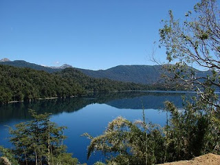
Known as the “Seven Lakes Route”, we will go along the section of National Route 234 that joins the districts of San Martín de los Andes and Villa La Angostura.
We will look at the main tourist corridor in the area, known world-wide for the matchless beauty of its landscapes, with panoramic natural vantage points, lakes, rivers and countless attractions opening up in front of those who are willing to discover, together with us, the real seven lakes route.
Rather than seven, we can see eight lakes along the road without taking any detour into lateral paths and going directly from San Martín to La Angostura. From North to South, the first one is Lake Lácar and next are the Machónico, Falkner, Villarino, Escondido, Correntoso, Espejo and Nahuel Huapi.

We leave from San Martín de los Andes, bordering Lake Lácar while we behold all its impressiveness. As we advance along a bendy road, we see how we leave the mountain village behind.
Having gone along approximately five kilometers, we come to a detour to the right which signpost reads "Playa Catritre" (Catritre beach), a heavenly site with a beach and suitable for camping with all services available.
There are 80 parcels available, a building with washrooms, showers and wash basins, grocery and a coffee-shop.
At kilometer 6 (always considering San Martín as kilometer 0), another detour into the right leads to Villa Quila Quina, a summer village which represents one of the best natural bathing resorts in the region. With a special micro climate, it is nestled in the very heart of the Mapuche Curruhinca community lands.
All this stretch of the road is paved and presents mild ascending bends.
15 kilometers ahead, the road leading to Mount Chapelco starts on the left. Kilometer 20 lodges the vantage point looking into the Arroyo Partido (split-up stream), a natural phenomenon. This stream opens up into two branches: the one on the right ends into the Pacific Ocean through the Lake Lácar basin, and the one on the left ends into the Atlantic Ocean through the Collón Curá, Limay and Negro Rivers basin.
Resuming our way, we get to an area known as "Las Taguas", where there are camping sites and cabins, on the river bank, near the park ranger house.
We continue our way till we cross the bridge over the Hermoso River. There, we get to a crossroads: the road on the left leads to Bariloche along the so-called Paso Córdoba, the shortest route to get to that city from San Martín but with abrupt ascents.
We choose the road on the right, which continues to our 7 lakes road. Shortly after leaving the bridge over the Hermoso River, among the trees on the right, we can see the Laguna Fría (cold lagoon), which sometimes gets frozen in the winter. It is not convenient to go down to its shores, as it is low and easily flooded. Some 500 meters ahead, the second lake appears: Lake Machónico, with its spectacular natural vantage point.
When we get to kilometer 35, there is another detour on the right leading to the Pudú – Pucú Lagoon and to Lake Hermoso.
This lake may not be seen from the road, as it is located four kilometers inland to the right. It is worth visiting. The rainforest frame that covers the slopes of nearby mounts and the deep blue of its waters quickly justify the choice for its name. There is a very good site for camping.
Back on the main road, for kilometers ahead, we cross the signpost signaling the border between the Lanín and the Nahuel Huapi National Parks, two of the wild protected areas that this corridor joins. The other National Park is Los Arrayanes, lying on the shores of Villa La Angostura.
It is convenient to slow down when approaching kilometer 43 and watch down to the right. As many visitors pass by at high speed, they miss the tremendous sight of the Vuliñanco Cascade, with its 35-meter high fall, dropping into two vertiginous arms because of an enormous rock that divides the waters.
Seven Lakes Route.

A few kilometers ahead, Lake Falkner comes into sight. At this point, it is convenient to watch the mount located on the southern bank. It has impressive black rock towers in its summit. It is Mount Buque. Condors make their nest there, therefore, it is possible to see them flying around. They are easily identified by their wingspan, their perfect hovering, their white spot on their neck and the almost vertical position of the feathers at the end of their wings.
On the shores of Lake Falkner, there is a wild area for camping on the sandy beaches, with bathrooms, fire sites, grocery, and it is open from November to April.
Connected with Lake Falkner, it opens before our eyes to the right of Lake Villarino, and to the left, the inn bearing the same name. When you leave it behind, you should draw your attention to the right, as at about 3 kilometers you can make out a small lake with emerald green waters among the vegetation: Lake Escondido with a small vantage point from where you may take pictures. Take into account that once you climb up by Lake Villarino and just before getting to Lake Escondido, the pavement ends and the rubble road begins.
After crossing the bridge over the Pichi Traful River, another minor path opens to the left. If you follow it, you can access Lake Pichi Traful after two kilometers, where there is a camping area and a spectacular sandy beach surrounded by exuberant vegetation. Farther on, following the route, the signposts on the left indicate the access to Lake Traful and to beautiful Villa Traful, along Provincial Route 65.
The next lake we find in our way is the Correntoso, which we cross again over the homonymous river, a few kilometers before reaching Villa La Angostura; 400 meters before getting to the bridge over the Ruca Malén stream, another access leading to Lake Espejo Chico is seen. After 2 kilometers among the forest, we find an ecological camping area.
Back on National Route 234, and once we cross the bridge over the Ruca Malén Stream, we can make a stop and watch the crystal clear green waters, the sunken logs and the ancient bridge over which the former road would pass and which today is part of the history of this seven lakes road.
After a steep climb along the road, to the right we see the small quiet Lake Bailey Willis (the ninth lake for many people), and 3 kilometers ahead on the left, an area of the old tract of the route. If we feel like hiking, we can walk along this route avoiding some logs and, after about 300 meters, reach the "Los Huillines" Lagoon.
Two kilometers ahead, we find one of the vantage points of Lake Espejo and some kilometers ahead, to our right, a road climbing towards another arm of Lake Espejo. A hotel resort with all the facilities by a beautiful beach and a camping area offers a choice to have a rest and make a stop on the way.
We get to kilometer 100 and to National Route 231, leading to the Cardenal Samoré international pass, which connects the area with the Puyehue zone and with the Carretera Panamericana de Chile level with the city of Osorno. If we take this road and go along about 1000 meters, we get to the spectacular vantage point over Lake Espejo. One photograph and we retrace our steps.
Resuming our way along the route, some kilometers ahead, a spectacular sight opens up before us overlooking the northern area of Lake Nahuel Huapi, the sixth lake in size in our country and the last lake in the circuit.
Shortly before getting to Villa la Angostura, another curiosity awaits on the road: the particular Correntoso River. This river joins the homonymous lake with the Nahuel Huapi, and due to its small size, it is the shortest river in the world, and one Mecca of sport salmon anglers par excellence.
Thus, we get to our final destination: Villa La Angostura, a typical mountain village offering all the services and where we can practice several activities: navigation, hiking, horse riding, mountain bikini or fishing from November to April. All this, within a frame of full nature.
If you liked this article, subscribe to the feed by clicking the image below to keep informed about new contents of the blog:


 In the Turist Information Center a very helpful (and proud) staff member gave us a brochure with a small map and told us how to come as close as possible to ‘La Paleta del Pintor’. This ‘Painter’s Palette’ is by far the most interesting sight in/nearby Maimará and for me one of the most beautiful parts of the Humahuaca Gorge.



