F
Showing posts with label Unesco. Show all posts
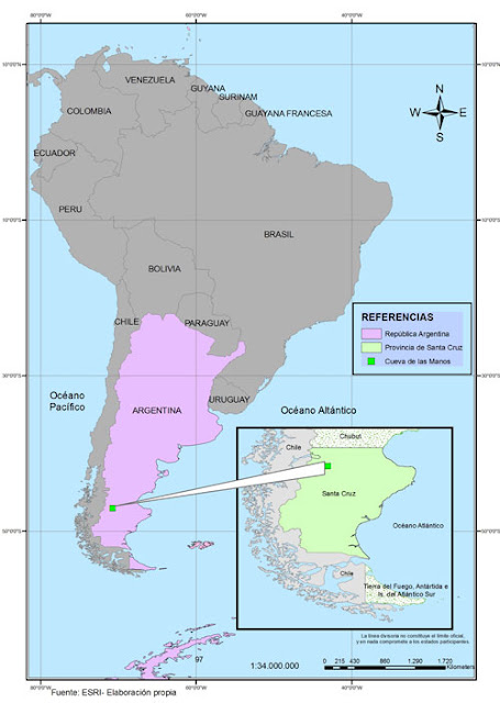
Surrounded by hundreds of kilometers only by the constant sound of the Patagonian wind, Pinturas River Canyon opens.

There, in the folds of its high walls, the rock art of Cuevas de las Manos, where settlers 9,000 years ago sealed their art and their witness of life is discovered.

His fame is not for nothing. Those hands, guanacos and geometrical figures stamped on the stone of the cave are the oldest expression, knowledge of South American peoples have.

This was understood by Unesco in 1999 when he was named Cultural Heritage.
cueva de las manos
Its location, lonely, amid the northwestern Santa Cruz steppe enables you kept almost intact.

The nearby as people, Perito Moreno, is 163 kilometers away. And beyond, and near the Cordilera, it is the ancients, who was the resting place of the elders of the missing Indian tribes.

This whole area and not just the cave, including NacionalPerito Moreno Park (not to be confused with the Glacier National Park, which preserves the Perito Moreno Glacier.

La Cueva de las Manos is a rich archaeological and paleontological site. The valleys, canyons, lakes and rivers that make up rock shelter celosamentepinturas and different types of archaeological sites in their fields men who walked 14,000 years BC.

And in the grass, sea fossils testify that this region was long before that old man dwell.
In fact, the town of Perito Moreno is called the archaeological capital of the Province of Santa Cruz.
If you liked this article, subscribe to the feed by clicking the image below to keep informed about new contents of the blog:
rss-icon-feed1
1.- The Los Alerces National Park boasts lovely and simultaneously protects forests of ancient larches.
The Los Alerces National Park boasts lovely and simultaneously protects forests of ancient larches.
The Los Alerces National Park is located in the west of the province of Chubut. It has an area of ​​259,570 hectares belonging to the Patagonian Forests ecoregion. Decree No. 1937 105 433 set for different areas in the Andean Patagonia status reserves bound for the subsequent creation of National Parks. One of these territories was the Reserve Larches.   In April 1945, through Decree

The Iguazu Falls are waterfalls generated by the Iguazu River located on the border of the Brazilian state of Paraná and the Argentine province of Misiones.

The system consists of cascades of 300 waterfalls, with heights up to 70 meters, along 2.7 miles of the Iguazu River. La Garganta del Diablo ("Devil's Throat"), a U-shaped gorge 150 meters deep and 700 meters long, is the most impressive, and marks the border between Argentina and Brazil.

iguazu_entrata

1.- Cycling the Abra del Acay.

Cycling the Abra del Acay.

Weds 14 Nov: San Antonio de los Cobres – La Poma (c. 2830m) (92km, 1350m ascent). The big day. We set off early, retracing to Los Patos and turning right. The route follows a stream through a broad valley, with a few settlements off the road. At 18km is what looks to be a good campsite (presumably the one used by Stefan Roman). 7km later there is a sandy stretch with no habitation beyond.

Read More ... »

1.- Cycling the Abra del Acay.

Cycling the Abra del Acay.

Weds 14 Nov: San Antonio de los Cobres – La Poma (c. 2830m) (92km, 1350m ascent). The big day. We set off early, retracing to Los Patos and turning right. The route follows a stream through a broad valley, with a few settlements off the road. At 18km is what looks to be a good campsite (presumably the one used by Stefan Roman). 7km later there is a sandy stretch with no habitation beyond.

Read More ... »

1.- Route 40 explained section by section: southern section.

Route 40 explained section by section: southern section.

Route 40 extends over 5000 kilometers in Argentina and unites some of the most beautiful and famous country territories. The trail crosses the Cuyo, North and Patagonia. It passes through 11 provinces, twenty National Parks and Reserves, 13 large lakes and salt mines, and five areas declared Natural Heritage Site. Kilometer 0 of Route 40 is the Cabo Virgenes in Santa Cruz, and it reaches its

Read More ... »

1.- Naveira Castillo Lujan incredible architectural beauty based on gothic structure.
Naveira Castillo Lujan incredible architectural beauty based on gothic structure.
Naveira Castillo incredible architectural beauty based on Gothic structure. One of the most mysterious and eccentric places in Argentina as it is forbidden to the public. The Naveira Castle is located in the town of Lujan, Province of Buenos Aires. The structure of this castle is based in Gothic art and is one of the most mysterious and eccentric places in the area that is forbidden to the

1.- Copahue could be named World Natural Heritage by UNESCO (Part II).

Copahue could be named World Natural Heritage by UNESCO (Part II).

Itineraries: The main attraction of the park are its hot springs. In Copahue are domesticated, they put at the service of health. But in Las Maquinitas, the Amphitheatre and the volcano crater, destination rides and guided walks, wild look in all its splendor. Also reach the border pillar Step Copahue 2013 mts., Where the Mapuche Chilean valley Trapa Trapa arrive daily to sell their crafts.

More »

2.- Copahue could be named World Natural Heritage by UNESCO (Part I).

Copahue could be named World Natural Heritage by UNESCO (Part I).

Exceptional features, it is one of the country's thermal havens Copahue Provincial Park, located northwest of the province of Neuquén, Patagonia Argentina, meets two criteria proposed for the assessment of outstanding universal value and to be declared a World Natural Heritage by the United Nations Organization. On the one hand, represent natural phenomena or areas of exceptional natural beauty

More »

3.- The 10 Most Popular Posts on Argentina Photo Gallery in January 2014.

The 10 Most Popular Posts on Argentina Photo Gallery in January 2014.

1.- Gualeguaychú Carnival The Carnival of the Country. As in previous years, during the next 2014 Summer months, on Saturdays (from January 4th to March 1st, and this Summer will also include March 2nd and 3rd -Sunday and Monday-), the city of Gualeguaychú will dress up to present one of the most expected shows in the area: the Gualeguaychu 2014 Carnival, which summons thousands of enthusiasts

More »

4.- Gualeguaychú Carnival The Carnival of the Country.

Gualeguaychú Carnival The Carnival of the Country.

As in previous years, during the next 2014 Summer months, on Saturdays (from January 4th to March 1st, and this Summer will also include March 2nd and 3rd -Sunday and Monday-), the city of Gualeguaychú will dress up to present one of the most expected shows in the area: the Gualeguaychu 2014 Carnival, which summons thousands of enthusiasts that enjoy the brightness, the joy, the thrill and the

More »

5.- Lagunas de Yala, water mirrors in height with a stunning vegetation.

Lagunas de Yala, water mirrors in height with a stunning vegetation.

Surrounding environment, Lagoons and wing are located in the Capital Department, to 2.306msnm In total there are six access but this will only enable them to three bodies of water that are in high amid lush greenery and looks like a mirage in the mountains, a dream. They are known as: The Noques, Alizar, The Trough, Drainage, Rodeo, Long. The thick vegetation and flowers form in an attractive

More »

6.- The 10 Most Popular Posts on Argentina Photo Gallery in December 2013.

The 10 Most Popular Posts on Argentina Photo Gallery in December 2013.

1.- Progressive disappearance of missionary fauna. The fauna of the province of Misiones, notable for its wonderful variety, was highly assaulted: one by the irrational and uncontrolled hunting of species with economic value (for their fur or leather), on the other removing the forest as natural... More » 2.- Andresito Provincial Park great exponent of the missionary nature. Among extensive

More »

7.- Progressive disappearance of missionary fauna.

Progressive disappearance of missionary fauna.

The fauna of the province of Misiones, notable for its wonderful variety, was highly assaulted: one by the irrational and uncontrolled hunting of species with economic value (for their fur or leather), on the other removing the forest as natural habitat, which significantly decreased the chances of survival of the species. As a result several species at virtual extinction was implemented to

More »

8.- Andresito Provincial Park great exponent of the missionary nature.

Andresito Provincial Park great exponent of the missionary nature.

Among extensive plantations of yerba mate blend with the forest vegetation, Andresito is a quiet town in the Province of Misiones which is located 60 miles from Niagara Falls, in the Department of General Belgrano. Combining natural landscapes with activities for everyone but always retain the native environment, ecotourism is positioned as one of the best ways to immerse yourself in this

More »

9.- International Exhibition Fair of Buenos Aires, The Book - From Author to Reader.

International Exhibition Fair of Buenos Aires, The Book - From Author to Reader.

The International Fair Exhibition of Buenos Aires, The Book - From Author to Reader's creation and entrepreneurship of the Book Foundation, a nonprofit based in Hipólito Yrigoyen 1628, 5th Floor, (C1089AAF) Buenos Aires. The Foundation is made up of the Argentina Society of Writers (SADE), the Argentina Book Chamber (CAL), the Argentina Chamber of Publishing, Industry Books and Magazines Spanish

More »

10.- The 10 Most Popular Posts on Argentina Photo Gallery in November 2013.

The 10 Most Popular Posts on Argentina Photo Gallery in November 2013.

1.- Teyú Cuaré Provincial Park (Misiones), inspirational writer Horacio Quiroga. Teyú Cuaré Provincial Park (in Guarani: Teju lizard kuaré, cave, ie: Cave lizard) is a protected area of Argentina province of Misiones. It covers a coastal area on the Paraná River located in the department of San Ignacio. It has an area of ​​78 ha. The place has inspired the Uruguayan writer Horacio Quiroga, who

More »

If you liked this article, subscribe to the feed by clicking the image below to keep informed about new contents of the blog:

talampayaTalampaya National Park is a national park located in the east/centre of La Rioja Province, Argentina. It was designated a provincial reserve in 1975, a national park in 1997, and a UNESCO World Heritage Site in 2000.

The park covers an area of 2,150 square kilometres (830 sq mi), at an altitude of 1,500 metres (4,921 ft) above mean sea level. Its purpose is to protect important archaeological and palaeontological sites found in the area. It has landscapes of great beauty, with flora and fauna typical of the mountain biome.
talampaya map
The park is in a basin between the Cerro Los Colorados to the west and the Sierra de Sañagasta to the east. The landscape is the result of erosion by water and wind in a desert climate, with large ranges in temperature - high heat by day and low temperature at night, with torrential rain in summer and strong wind in spring.

The park includes:
    The dry bed of the Talampaya River, where dinosaurs lived millions of years ago - fossils, whilst not as interesting as Ischigualasto, have been found here;
    The Talampaya gorge and its rock formations with walls up to 143 metres (469 ft) high, narrowing to 80 metres (262 ft) at one point;
    The remains of indigenous peoples' settlements, such as the petroglyphs of the Puerta del Cañón;
    A botanical garden of the local flora at the narrow point of the canyon;
    Regional fauna, including guanacos, hares, maras, foxes and condors.
Talampaya emblema


If you liked this article, subscribe to the feed by clicking the image below to keep informed about new contents of the blog:
 
Copyright © 2015 Argentina Photo Gallery
Distributed By Gooyaabi Templates
-->