F
The ruins of Quilmes can be reached from Cafayate (Salta) or from Tafi del Valle (Tucumán).

This location is just stunning, unique and majestic.

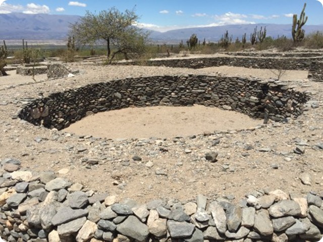
The ruins of Quilmes, as they are known, belonged to the Calchaquí natives who settled on the hillsides and on the mountain range called Calchaquí, from which the tribes got their name: Quilmes and Calchaquí.
Ruinas_Quilmes1

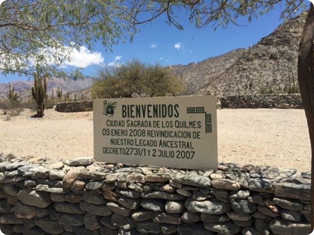
The Ruins of Quilmes are a true cultural heritage of indigenous culture.

About 5,000 people resided the area starting about 850 AD.  For almost 100 years prior to the arrival on the Spaniards, about 1530, the Quilmes fiercely fought the Incas who came south from Peru. 

Location.

quilmes-ruinas
The ruins are located at an altitude of about 2,000 meters (6,500 + feet) elevation. 


The ruins were rediscovered about 1890.  Work was started to restore the ruins in 1978.

My tour guide told me that only about 10 % of the ruins have been restored. 
Read also: Colony of Magellanic Penguins in Peninsula Valdes.
Satellite pictures of both the general area of the ruins and the restored areas are shown below.

Restored area of Ruinas de los Quilmes.

Only about 10% of the ruins have been restored.  This view is courtesy of Bing Maps.
quilmes-ruinas.-original-area


quilmes-ruinas.-restored-area

Conclusion.

I did not know anything about the Quilmes prior to my visit to San Miguel de Tucuman.  I think this was the most interesting part of the visit.  RIQ is just not on the same scale of Machu Picchu (home of the ruler of the Incas). 
The Ruins of Quilmes are a true cultural heritage of indigenous culture.Click to Tweet


What I did learn today was a better appreciation of how large the Inca Kingdom really was, the will the the Quilmes to maintain their freedom from both the Incas and Spaniards, and how in the end they were hauled away as slaves.  It is a great story of the struggles of one of the many indian tribes in South American to maintain their independence for over 800 years.
Images Gallery.
ruinas_Viviendas_QuilmesRuinasdeQuilmes
quilmes-ruinas-1quilmes-ruinas-cactusquilmes-ruinas-cartelquilmes-ruinas-rooms
If you liked this article, subscribe to the feed by clicking the image below to keep informed about new contents of the blog:
rss-icon-feed1
The National Park Lago Puelo is one of the most beautiful and unique reserves of PatagoniaThe Lago Puelo National Park  is a national park of Argentina, located in the northwest of the province of Chubut, in the Patagonia.

It has an area of 276.74 km². It was created in order to protect its wonderful landscape and the Valdivian flora, as an annex to the Los Alerces National Park, and declared National Park and independent reserve in 1971.


The National Lago Puelo.

The protected area is named after the Puelo Lake, and belongs to the Patagonic forest and steppes and High Andes eco-regions, with maximum heights of two hundred meters over sea level.

The mountainous zone where the park lies was modified by the action of glaciers, which created many rivers and lakes, including the one (Puelo Lake) that gives the park its name. The rivers of the region show high levels of glacier sediment (silt), which gives Puelo Lake its blue color.

The National Park Lago Puelo is one of the most beautiful and unique reserves of Patagonia.Click To Tweet

Climate.

The climate is cold and wet, although more temperate than other parks in the region.Mean temperatures range from 5 °C (41.0 °F) in winter to 17 °C (62.6 °F) in summer. Mean annual precipitation is around 1,400 mm (55 in), most of it being concentrated between May to August. Occasionally, snowfall can occur during the coldest months.

Flora and Fauna.

Some of the flora of the park belongs to the Valdivian rain forests (avellano, tique, lingue, ulmo). It also includes the ciprés de la cordillera, the coihue, the lenga, the radal, and the arrayán. The rosa mosqueta is an exotic plant.

The fauna includes the pudú, the huemul, the red fox, the cougar, and the coipo. Among birds we find the huala, the pato vapor volador, the bandurria, the pitío and the zorzal patagónico.


The lake features native fish such as the perca, the peladilla and the puyén grande, and foreign species of trout.

History.

If you liked this article, subscribe to the feed by clicking the image below to keep informed about new contents of the blog:
rss-icon-feed1


The south of Chile and Argentina is a hiker’s dream.

The melange of craggy mountains crowned with glaciers and glistening with waterfalls, scrubland dotted with pale glacial lakes, flowering meadows, marshlands, and windblown cliffs that skirt the Magellan Strait present countless opportunities for exploration on foot.

 Mt. Fitzroy starts to clear, just 1.5 hours walk, one way, from El Chalten in Parque Nacional Los Glacieres. From day hikes to a week-long trek around Tierra Del Fuego’s most inhospitable mountain range, here are our five favourite hikes in the region.

El Chalten Activities.

El Chalten ( pop. 140 and growing rapidly), a tiny and imperfectly formed village four hours by bus from El Calafate gives easy access to possibly Argentina's best hiking, ice treks and climbing in the Andean peaks of Los Glaciares National Park in Patagonia.
The best hiking in Patagonia and Tierra Del Fuego, El Chaltén.Click To Tweet

Hiking.

Mt. Fitzroy is the undisputed king of this castle, with Cerro Torre next in line.
The walks are magnificent, well marked and range from about one hour to seven hours (one-way), with most around three or four hours one-way. The average gradient rise during that time is about 300metres.

Other areas with first-class mountain hikes in Argentina are Ushuaia, Bariloche and Mendoza.
argentina-el-chalten-trail2-1000
A typically easy hiking trail in the El Chalten area. And no altitude problem!
The Rio de las Vueltas flood plain in the centre and backed by the Cordon de los Condores mountain range. Of course, if you prefer a tough trekking challenge there are plenty of hikes that will ring your bell!

Best Hiking Season.

The very best hiking months in Patagonia are March and November with fewer bugs, neither too hot nor too cold, no snow on trails but snow up high.
Summer is OK and runs from December to February but the narrow trails get congested, facilities are more costly, big bugs appear and plenty of them, and hiking becomes warm work. Winter is from May-August with snow in the valley and deep drifts higher up.
argentina-el-chalten-trail3-1000
A hiking trail in the next valley to El Chalten.
el-chalten-village-1000
Argentina's newest town/village, El Chalten.

Chalten Village.

Hurriedly slapped together in 1985 to claim the land before Chile could get their hands on it, Argentina's El Chalten is an uncontrolled mess of randomly sized, styled and placed buildings in varied materials and colours, replete with half-dug trenches, dangling cables and carpets of dandelions. El Chaos would be a better name for the place. This is tragic because the location is totally magical and deserves a coherent, well-constructed base, not a half-assed mishmash of partly-assembled junk.

Is there a governor out there? If so, he should be strapped to Fitzroy's heights until his head clears.
On the positive side, there are some excellent people, hostels and eateries in El Chalten and the trekking is stupendous.

parque-nacional-los-glacieres-lago-de-las-tres-wtw-1000
Mt Fitzroy - from a different angle - and two of the Lago de Los Tres. Photo by Chris Schoenbohm.

This is a longer route to Mt Fitzroy than the photo at top, curving around to approach from the west. Ours was about 8 miles round trip while the Lago de Los Tres is about 15 miles (25kms) with a 700m vertical. That neatly demostrates the versatility of El Chalten's hikes - same base, same destination, same rock and awe - but one pair of easygoing hikers versus one group of trail-hardened trekkers.
el-chalten-mt-fitzroy-hikers-1000
Cerro Torre on the right and Glacier Grande on the left, a three hour hike, one way from El Chalten.

Hiking is the clearly favourite activity in the Andes foothills around El Chalten. 


The walks are as easy or difficult as you choose to make them. We're not hardened hikers but really enjoyed the cool - but not cold - reasonably flat trails up to the Andes range, taking from a couple of hours return to eight hours, depending on how much time was 'wasted' just looking at the incredible panoramas. We stayed away from actual snow walking but got very close.

Images Gallery.

el-chalten-fishing-1000
Fly fishing is another popular activity in Patagonia.
el-chalten-jason-hollinger-1000
And then there's cycling...Photo by Jason Hollinger
Read also: The Piltriquitron is considered a reservoir of positive energy.
el-chalten-trail-horses-1000
....or horseback riding, pony trekking, whatever, four legs good...
el-chalten-forest-1000
...or even bird watching apparently, though we didn't see many twitterers.
el-chalten-forest-face2-1000
If you liked this article, subscribe to the feed by clicking the image below to keep informed about new contents of the blog:
rss-icon-feed1
 
Copyright © 2015 Argentina Photo Gallery
Distributed By Gooyaabi Templates
-->