Aconquija National Park is part of the new series of national parks established by Argentina from the 90s as a result of a policy aimed at protecting and sustaining environmental development in full respect of nature and biodiversity.
And as part of the Argentine parks, it stands out for the absolutely natural and virgin environment that encompasses its entire surface, where many endangered plant and animal species are protected, guarded and respected.
The Aconquija mountain range is formed by steep mountains. Large differences in altitude in few kilometers allow the existence of a very diverse environmental gradient. The lower portions of the mountains up to 3000 meters high constitute the Yungas eco-region, with its subtropical mountain forests. Above the forest strata, mountain meadows, rocky outcrops, meadows and permanent snow are found.
Heavy rains and mountain springs give rise to many permanent rivers and streams that flow to the plain, and feed the main basin of Tucumán, Santiago del Estero and the north of the Province of Córdoba. Many cities, villages and most of the agricultural and livestock production of the region depend on the water flowing from these mountains.
The most advisable thing is to leave from Tucumán to Concepción along National Route 38, approx. 75 km. from Concepción to Alpachiri by National Route 65, approx 17 km and from there by provincial route. 330 (consolidated gravel road 12 km to the entrance to the Park and 3 km more to reach the public use area in the Santa Rosa area.
Another alternative means of transportation is to reach the capital of Tucumán where buses arrive from all over the country and daily flights from Buenos Aires and Córdoba.
To reach the protected area you can get to Concepción and even Alpachiri by public transport and from there rent a car, hire a remise or resort to a tourism agency (the buses leave in Alpachiri, 12 km away).
It is also possible to rent a van in Concepción.
As commented in the parks, the ** Aconquija National Park houses a particular sample of the eco-regions of the Yungas, the High Andes and the transition environments (ecotones) between the two.
An exponent of the Yunga and Altoandina ecoregions, the protected area conserves the headwaters of the Jaya and Las Pavas rivers, which, lying on the eastern slopes of the Aconquija mountains, carry their waters to the valleys and cultivation fields of Tucumán.

Although the jungle flora is lavish in tree species, the presence of the alder of the hill deserves to be highlighted, which gives its name to the Campo de los Alisos portal.
Although it also grows in the jungle, this species is characteristic of the Montane Forest between 1,500 and 2,000 meters above sea level, where it forms almost pure associations.
It is considered a very useful species to fix and protect degraded soils, due to its rapid growth and ability to fix atmospheric nitrogen.


And as part of the Argentine parks, it stands out for the absolutely natural and virgin environment that encompasses its entire surface, where many endangered plant and animal species are protected, guarded and respected.
 |
| The incredible sensation of feeling the clouds above our heads. |
Aconquija National Park, spectacular landscapes, high biodiversity, archaeological and cultural values.
The Aconquija mountain range is formed by steep mountains. Large differences in altitude in few kilometers allow the existence of a very diverse environmental gradient. The lower portions of the mountains up to 3000 meters high constitute the Yungas eco-region, with its subtropical mountain forests. Above the forest strata, mountain meadows, rocky outcrops, meadows and permanent snow are found.
Heavy rains and mountain springs give rise to many permanent rivers and streams that flow to the plain, and feed the main basin of Tucumán, Santiago del Estero and the north of the Province of Córdoba. Many cities, villages and most of the agricultural and livestock production of the region depend on the water flowing from these mountains.
 |
| The low mountains are the dominant element in Aconquija National Park. |
How to get.
The most advisable thing is to leave from Tucumán to Concepción along National Route 38, approx. 75 km. from Concepción to Alpachiri by National Route 65, approx 17 km and from there by provincial route. 330 (consolidated gravel road 12 km to the entrance to the Park and 3 km more to reach the public use area in the Santa Rosa area.
 |
| The characteristic fauna is varied and abundant. |
To reach the protected area you can get to Concepción and even Alpachiri by public transport and from there rent a car, hire a remise or resort to a tourism agency (the buses leave in Alpachiri, 12 km away).
It is also possible to rent a van in Concepción.
Yungas Ecosystem.
As commented in the parks, the ** Aconquija National Park houses a particular sample of the eco-regions of the Yungas, the High Andes and the transition environments (ecotones) between the two.
 |
| The lower zone of the Yungas has a climate from tropical to subtropical, rainy and cloudy. |
Jungle flora is abundant in tree species.

Although the jungle flora is lavish in tree species, the presence of the alder of the hill deserves to be highlighted, which gives its name to the Campo de los Alisos portal.
Although it also grows in the jungle, this species is characteristic of the Montane Forest between 1,500 and 2,000 meters above sea level, where it forms almost pure associations.
It is considered a very useful species to fix and protect degraded soils, due to its rapid growth and ability to fix atmospheric nitrogen.
The fauna registers more than 400 species.
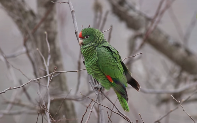
The Smooth Parrot is one of the most representative bird species in Aconquija National Park.
The fauna is not far behind in terms of diversity. So far, more than 400 species of vertebrates have been registered, among which are guanacos, river wolves, the Andean cat, the mountain frog and the ocelot.Read also: A virtual journey through the national parks of Argentina (#2): Baritú, protected natural area.A separate paragraph corresponds to the Smooth Parrot, an endemic species of the Yunga of northwestern Argentina and southern Bolivia. This parrot nests only in the Montane Forest, between November and March. During the winter, it forms flocks that go to the lower areas to feed on the fruits of the cebil fork and other plants in the foothills.

There have been registered the presence of wild guan (Penelope obscura), aquatic birds such as the torrent duck (Merganetta armata) and the white heron (Ardea alba), the maitaca parrots (Pionus maximiliani), chatty (Amazona aestiva) and the red-faced calancate (Psittacara mitratus), raptors such as the common harrier (Geranoaetus polyosoma) or the carancho (Caracara plancus), to which several dozen songbirds are added.
A separate paragraph corresponds to the Smooth Parrot, an endemic species of the Yunga of northwestern Argentina and southern Bolivia. This parrot nests only in the Montane Forest, between November and March. During the winter, it forms flocks that go to the lower areas to feed on the fruits of the cebil fork and other plants in the foothills.


Between 1,000 and 1,500 meters above sea level, the montane jungle begins, characterized by its high density and the presence of walnut (Juglans australis), Tucumán cedar (Cedrela lilloi), elderberry (Sambucus peruvianus), hill laurel (Phoebe porphyria), the horbil cebil (Piptadenia excelsa), the cochucho (Fagara coco), the mato (Eugenia pungens), palo San Antonio (Rapanea laetevirens), the bouquet (Cupania vernalis) and the shawl (Allophylus edulis), among others.
Flora.
 |
| These large trees are usually practically covered with epiphytes such as some orchids and the carnations of the common air (Tillandsia pulchella) and giant (Tillandsia maxima), among others. |
In the foothill jungle the predominant plant species are alder (Alnus acuminata), characteristic of montane forest between 1500 and 2000 meters above sea level, cebil (Parapiptadenia excelsa), tipa (Tipuana tipu), laurel (laurus nobilis), the tarco (Jacaranda mimosifolia), the yellow drunk stick (Chorisia insignis) and the horco molle (Blepharocalyx gigantea) among others.


Between 1,000 and 1,500 meters above sea level, the montane jungle begins, characterized by its high density and the presence of walnut (Juglans australis), Tucumán cedar (Cedrela lilloi), elderberry (Sambucus peruvianus), hill laurel (Phoebe porphyria), the horbil cebil (Piptadenia excelsa), the cochucho (Fagara coco), the mato (Eugenia pungens), palo San Antonio (Rapanea laetevirens), the bouquet (Cupania vernalis) and the shawl (Allophylus edulis), among others.
 |
| After 1,500 m, the montane forest continues, where alders of the hill (Alnus jorullensis) and pine trees of the hill (Podocarpus parlatorei) are found, which disappear to give rise to the tall meadow, with groups of queñoa (Polylepis australis) |